Loading...
Way History: 200605804
Version #4
removing quality tags
Tags
| source:geometry | Institut géographique militaire/Militair geografisch instituut, Military staff map (available on kbr.be and http://cartesius.be/) |
|---|---|
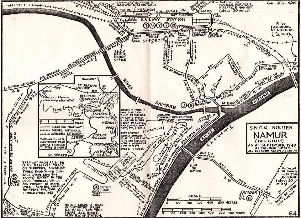
| source:geometry2 | (map) JC Gillham, S.N.C.V. Routes Namur (Belgium) as at september 1949 gauge-one metre. all electric except as shown https://i.goopics.net/7clva3.jpg |
| source:geometry:guide | Service public de Wallonie (SPW), most recent aerial imagery https://geoportail.wallonie.be/ |
| source:geometry:guide:date | 2024 |
| source_type | railway |
| type | source |
Nodes
35 nodes
- 2125550432 (part of way 200606068)
- 2125548558
- 2125548557
- 2125548556
- 2125548555
- 2125548554
- 2125548553
- 2125548552
- 2125548551
- 2125548550
- 2125548549
- 2125548548
- 2125548547
- 2125548546
- 2125548545
- 2125548544
- 2125548543
- 2125548542
- 2125548541
- 2125548540
- 2125548539
- 2125548538
- 2125548537
- 2125548536
- 2125548535
- 2125548534
- 2125548533
- 2125548532
- 2125548531
- 2125548530
- 2125548529
- 2125548528
- 2125548527
- 2125548526
- 2125548574 (part of way 200605806)
Version #3
(no comment)
Tags
| quality | 1 |
|---|---|
| source:geometry | Institut géographique militaire/Militair geografisch instituut, Military staff map (available on kbr.be and http://cartesius.be/) |
| source:geometry2 | (map) JC Gillham, S.N.C.V. Routes Namur (Belgium) as at september 1949 gauge-one metre. all electric except as shown https://i.goopics.net/7clva3.jpg |
| source:geometry:guide | Service public de Wallonie (SPW), most recent aerial imagery https://geoportail.wallonie.be/ |
| source:geometry:guide:date | 2024 |
| source_type | railway |
| type | source |
Nodes
35 nodes
- 2125550432 (part of way 200606068)
- 2125548558
- 2125548557
- 2125548556
- 2125548555
- 2125548554
- 2125548553
- 2125548552
- 2125548551
- 2125548550
- 2125548549
- 2125548548
- 2125548547
- 2125548546
- 2125548545
- 2125548544
- 2125548543
- 2125548542
- 2125548541
- 2125548540
- 2125548539
- 2125548538
- 2125548537
- 2125548536
- 2125548535
- 2125548534
- 2125548533
- 2125548532
- 2125548531
- 2125548530
- 2125548529
- 2125548528
- 2125548527
- 2125548526
- 2125548574 (part of way 200605806)
Version #2
(no comment)
Tags
| quality | 1 |
|---|---|
| source:geometry | Institut géographique militaire/Militair geografisch instituut, Military staff map (available on kbr.be and http://cartesius.be/) |
| source:geometry2 | (map) JC Gillham, S.N.C.V. Routes Namur (Belgium) as at september 1949 gauge-one metre. all electric except as shown https://i.goopics.net/7clva3.jpg |
| source:geometry:guide | Service public de Wallonie (SPW), most recent aerial imagery https://geoportail.wallonie.be/ |
| source:geometry:guide:date | 2024 |
| source_type | railway |
| type | source |
Nodes
42 nodes
-
2125548566 -
2125548565 -
2125548564 -
2125548563 -
2125548562 -
2125548561 -
2125548560 -
2125548559 - 2125548558
- 2125548557
- 2125548556
- 2125548555
- 2125548554
- 2125548553
- 2125548552
- 2125548551
- 2125548550
- 2125548549
- 2125548548
- 2125548547
- 2125548546
- 2125548545
- 2125548544
- 2125548543
- 2125548542
- 2125548541
- 2125548540
- 2125548539
- 2125548538
- 2125548537
- 2125548536
- 2125548535
- 2125548534
- 2125548533
- 2125548532
- 2125548531
- 2125548530
- 2125548529
- 2125548528
- 2125548527
- 2125548526
- 2125548574 (part of way 200605806)
Version #1
(no comment)
Tags
| quality | 1 |
|---|---|
| source:geometry | Institut géographique militaire/Militair geografisch instituut, Military staff map (available on kbr.be and http://cartesius.be/) |
| source:geometry:guide | Service public de Wallonie (SPW), most recent aerial imagery https://geoportail.wallonie.be/ |
| source:geometry:guide:date | 2024 |
| source_type | railway |
| type | source |
Nodes
42 nodes
-
2125548566 -
2125548565 -
2125548564 -
2125548563 -
2125548562 -
2125548561 -
2125548560 -
2125548559 - 2125548558
- 2125548557
- 2125548556
- 2125548555
- 2125548554
- 2125548553
- 2125548552
- 2125548551
- 2125548550
- 2125548549
- 2125548548
- 2125548547
- 2125548546
- 2125548545
- 2125548544
- 2125548543
- 2125548542
- 2125548541
- 2125548540
- 2125548539
- 2125548538
- 2125548537
- 2125548536
- 2125548535
- 2125548534
- 2125548533
- 2125548532
- 2125548531
- 2125548530
- 2125548529
- 2125548528
- 2125548527
- 2125548526
- 2125548574 (part of way 200605806)
Welcome to OpenHistoricalMap!
OpenHistoricalMap is an interactive map of the world throughout history, created by people like you and dedicated to the public domain.
OpenHistoricalMap is a charter project of OpenStreetMap U.S., a 501(c)(3) nonprofit organization affiliated with the OpenStreetMap Foundation. Technical development is supported by GreenInfo Network and Development Seed.
| https://openstreetmap.org/copyright | https://openstreetmap.org |
| Copyright OpenHistoricalMap and contributors, under an open license | |