Loading...
Way History: 200417893
Version #4
Red Arrow lines
Tags
| quality | 2 |
|---|---|
| source | Photographs/videos http://u.osmfr.org/m/963936/ |
| source_type | railway |
| type | source |
Nodes
2 nodes
-
2123026413 - 2123026412 (part of ways 200419626, 200419639, and 200424240)
Version #3
Tagging : replacing start date/end date:note arbitrary with star/end_date:fixme=arbitrary
Tags
| quality | 1 |
|---|---|
| source | Lansdowne, PA, 1942 https://ngmdb.usgs.gov/topoview/ |
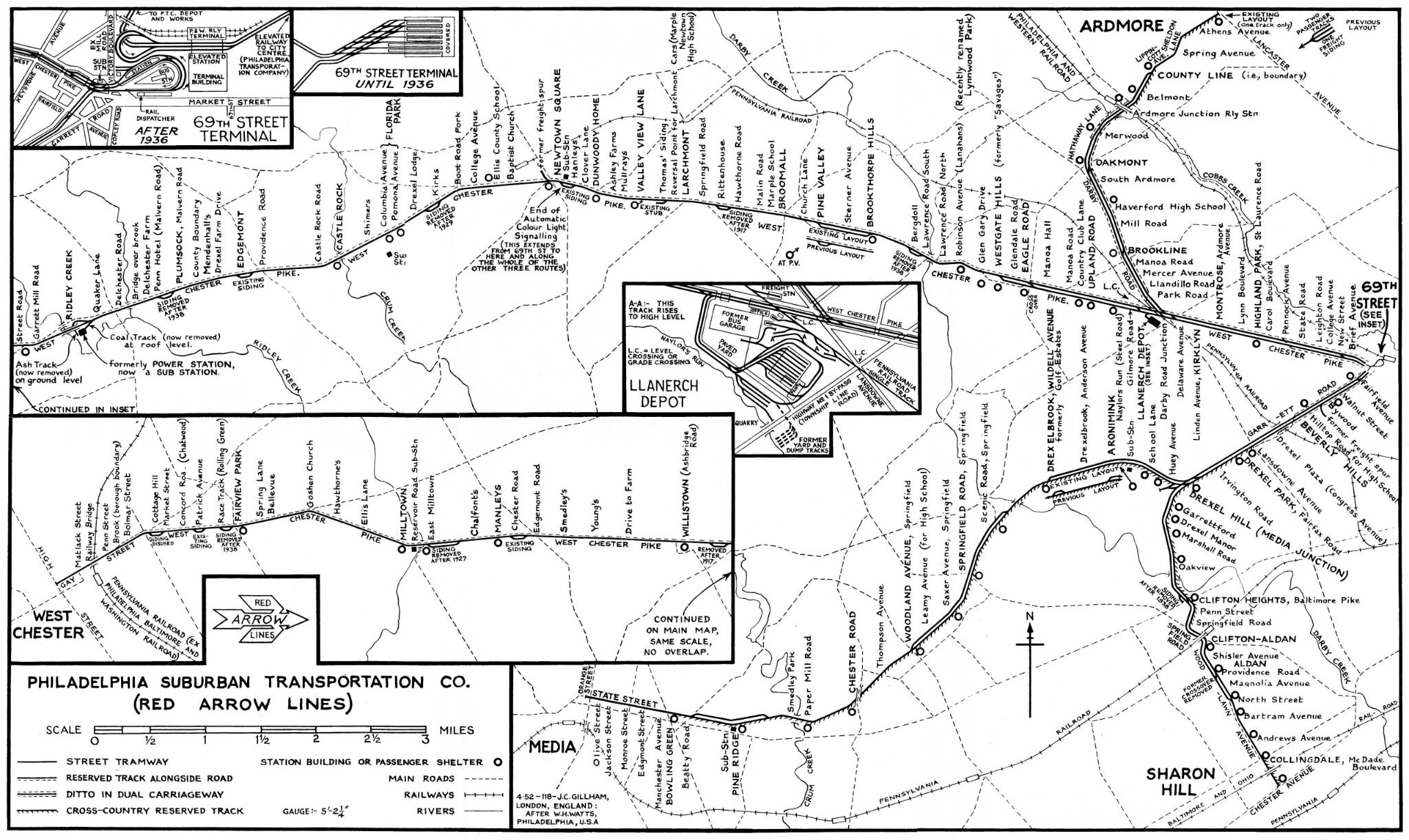
| source2 | (map) Philadelphia Suburban Transportation Co. (Red Arrow Lines) 1952, collection & restauration Jim Dornberger https://i.goopics.net/fux1g2.jpg |
| source_type | railway |
| type | source |
Nodes
2 nodes
-
2123026413 - 2123026412 (part of ways 200419626, 200419639, and 200424240)
Version #2
Red Arrow lines
Tags
| quality | 1 |
|---|---|
| source | Lansdowne, PA, 1942 https://ngmdb.usgs.gov/topoview/ |
| source2 | TRACKS MAP |
| source_type | railway |
| type | source |
Nodes
2 nodes
-
2123026413 - 2123026412 (part of ways 200419626, 200419639, and 200424240)
Version #1
Red Arrow lines
Tags
| quality | 1 |
|---|---|
| source | Lansdowne, PA, 1942 https://ngmdb.usgs.gov/topoview/ |
| source_type | railway |
| type | source |
Nodes
2 nodes
-
2123026413 - 2123026412 (part of ways 200419626, 200419639, and 200424240)
Welcome to OpenHistoricalMap!
OpenHistoricalMap is an interactive map of the world throughout history, created by people like you and dedicated to the public domain.
OpenHistoricalMap is a charter project of OpenStreetMap U.S., a 501(c)(3) nonprofit organization affiliated with the OpenStreetMap Foundation. Technical development is supported by GreenInfo Network and Development Seed.
| https://openstreetmap.org/copyright | https://openstreetmap.org |
| Copyright OpenHistoricalMap and contributors, under an open license | |